Sunday, February 3, 2013

Density by Chris Brown - 2/2/13


It's really hard how to find out how much density an object has, right? Wrong. It's really quite easy. All you have to do is use the formula of density: density=mass/volume.  A very easy way to remember this is to think of a broken heart. The "M" for mass, divided by a "V" for volume creates the shape of a heart cut in half by a division symbol. If an object or certain material is more dense than the molecules of that object or material are tightly packed together, and if a object has a lower density than the molecules are less closely packed together.
(Lead has a very high density)
(Wood has a very low density)

(Density formula picture)


To find the density of an object you need to first find the volume of that object. There are a few different ways to do this, If the object is a regular shape than you can mesure it, if the object is irregular than you use the water displacement method. When you are finding the volume of an object by measuring it, for example a cube. You need to find three different measurements, the length of the cube, the width of the cube and hight of the cube, this can be remembered as LxWxH.


(http://upload.wikimedia.org/wikipedia/commons/e/ec/IsometricCubeGray.png)

When calculating the volume of an irregular object using water displacement you need a few different materials. A graduated cylinder, water and of course the object. When you are finding the volume using water displacement there is one key thing that you have to keep in mind, the meniscus of the water in the graduated cylinder. A meniscus is a crescent shape on the upper surface of a liquid. When measuring how far the water has risen you have to always mesure to the bottom of the meniscus. 


(http://www.esu.edu/~scady/07424717.jpg)


A rock is an example of a irregularly shaped object. When trying to find the volume of a rock you have to use the water displacement method. You first put the rock into a graduated cylinder full of water. To find the volume of the rock you see how far the water rose when the rock was put into the water. For example, if the water level started at 10ml and when the rock was placed into the water the water level went up to 15ml, than the volume of the rock is 5ml.
(http://www.cstephenmurray.com/onlinequizes/chemistry/measuring/Dinocopy.jpg)

While trying to understand density we did the "Mystery Liquids-Rainbow straws lab". During the lab we tried to find the order of how dense all the liquids were. To do this we had to put two different liquids into a small straw and find which one was denser. We then took the liquid that was more dense and compared it to another liquid to see the more dense liquid out of those two. We continued to do this until we found the order of the liquids from least dense to most dense. 


(http://density-whatitmeans.wikispaces.com/file/view/density_layers/285963846/240x299/density_layers)

Another lab that we did was the "Density Bottles Lab". In this lab we were given a bottle with different colored beads inside and what at first looked like water surrounding all the beads. When the bottle is first shook all of the beads mix together in a random order, but after a few seconds they start to settle down and the blue beads went to the bottom of the bottle and the white beads went to the top. As you continue to wait both colors of beads start to move to the center. The beads eventually come together in the very middle of the bottle, the white beads on the top and the blue beads on the bottom. When we look at this more closely we see that there is not just water in the bottle but also another liquid (Rubbing alcohol) that has a density that is almost the exact same as the density of water but is just a little bit less dense. This lab helps us learn a couple different things. One, that rubbing alcohol is less dense than water, and two, that the material on top is the least dense, while the material on the bottom is the most dense.


(http://cdn.teachersource.com/images/products/pop/den460.jpg)

A third lab we did during the density unit is the "lava Lamp Density Exploration Lab". This lab was ment to show us that when a something is heated it becomes less dense and when something cools down it becomes more dense. Inside of a lava lamp there is a small light, this light heats the lava and makes the lava rise to the top of the lamp. When the lava at the top of the lamp starts to cool down it starts to go back down towards the heat source again. when the colder lava comes into contact with the heat again it starts to rise again creating a convection current of the lava moving in a circle.


(http://www.spencersonline.com/images/spencers/products/interactivezoom/processed/00530790.interactive.a.jpg)


Faults/Stress by Sunjae Lee 2/3/2013

For the past few weeks we have been learning about faults and stress, but what exactly are faults and stress? Well to start off a fault is a break in the crust where slabs of crust slip past each other. There are three main types of faults which are the strike-slip faults, normal faults, and reverse faults. You can find these faults along plate boundaries. Along with faults you will also find something called stress. Stress is a force which is used to change the shape and volume of rock. Like faults there are three different types of stress which are shearing, tension, and compression. Each type of stress goes with a specific type of fault.
First let's talk about a strike-slip fault. Strike-slip faults are the result of when the rocks on either side of the fault slip past each other in a sideways motion. The type of stress which fits the strike-slip fault is shearing. Shearing pushes the mass of rocks into two opposite direction and can cause the rock to break and slip apart to change its shape. Shearing caused strike-slip faults to occur in areas which had a transform boundary. You can see strike-slip faults across the world, an example would be the Sand Andreas fault in California.
 San Andrea's Fault
Source:http://www.sanandreasfault.org/4020_A.jpg

Next let's talk about what a normal fault is. Normal faults are faults which are at an angle and one block of rock is on top of the other rock. The half of the fault which is angled like a slide is called the footwall and the half of the fault which is shaped kind of like a cliff is called the hanging wall. In a normal fault the footwall is above and the hanging wall is below the footwall. Normal faults are paired up with tension which means that tension is causing the rock to be pulled at both sides of it and is causing it to become thinner in the middle. The tension's force causes the normal faults to appear where plates are diverging which means pull apart. An example of a normal fault can be seen in the Sandia Mountains in New Mexico which had created the mountain.
A picture of the Sandia Mountains in New Mexico
Source:http://www.filmapia.com/sites/default/files/imagecache/imgpreset_Scene_OnNode/filmapia/pub/place/sandia_mountains.jpg
Lastly let's talk about reverse faults. Basically the reverse fault is the exact same as a normal fault...except for one difference. Instead of the footwall being above the hanging wall this time it is the opposite with the footwall being below the hanging wall. Reverse faults are produced by the force of compression. Compression is a type of stress which squeezes the rock until it folds or break, and a plate pushing against another can cause the the rock to compress like a giant trash compactor. You can see reverse faults in areas with convergent boundaries, an example would be Mt. Gould in Glacier National Park.

For one of the homework's we were able to learn more about these concepts, and in class were able to visually see the motions with wooden blocks and review what we had learned the previous night.
For example, if we think about the reverse faults motion the footwall would move below the hanging wall. But for some people it would be hard to visualize, so to help understand the concept and the motion we used  wooden blocks to demonstrate it.
Visual of the motion of a Reverse Fault
Source: http://www.tulane.edu/~sanelson/images/reverse.gif
Then we would also be able to tell that it would have compression as the stress because the rocks are squeezing against each other. (We could also tell where it occurs which is at a converging plate.)
We could also visualize with the wooden blocks what a normal fault is since we know it is the opposite of a reverse fault.
Visual of the motion of a Normal Fault
Source: http://hays.outcrop.org/images/lutge8e/Chapter_17/Text_Images/FG17_12A.JPG
Since a normal fault is the opposite of a normal fault we could figure out that it has tension as the stress and is found at areas where it is diverging.)
The only different one would be the strike-slip fault, though it easy because the motion is just two "wooden blocks" sliding past each other in opposite directions.
Visual of the motion of a Strike-Slip Fault
Source:http://geomaps.wr.usgs.gov/parks/deform/strikeslip.gif
You can tell from this information that it would have shearing as the stress and it would be in an area which has transform plates.

Now based on what you learned can you match these stresses and faults to each other?:
Source:http://www.eas.purdue.edu/mesozoic/Lab_12/Stress_Types.jpg
Source:https://upload.wikimedia.org/wikipedia/commons/thumb/7/77/Fault_types.svg/382px-Fault_types.svg.png

Sunday, December 16, 2012

Plate Tectonics by Blake Harris - 12/16/12


Have you ever stood on a beach in California wondering why Asia is coming towards you so fast? Probably not, because continents don’t move nearly this quickly. The rate of continental drift is only five centimeters per year. Even if you stood on that beach for your whole life, you wouldn notice anything.
The plate tectonics theory is the theory that Earth’s lithosphere (the top of the mantle and bottom of the crust) is divided up into separate pieces, called plates, that slowly move around on top of the asthenosphere. There are 13 plates, each a different size and shape, and each carrying either continents, seafloor, or both. Earth’s plates are constantly in motion, being pushed apart from each other or towards each other. Plates are moved by convection currents located in the mantle. Evidence that supports the theory of plate tectonics are volcanoes, mountains, trenches and faults. Other evidence that supports this theory are eruptions and earthquakes.   


At all convergent plate boundaries, two plates will move towards each other, causing the two plates to collide. If the two plates are both continental crusts, and since they have the same density, neither one will subduct under the other and they will crumple up to form a mountain range. This collision also will cause an earthquake to occur. An example of this type of convergent boundary is the Indian Plate pushing up against the Eurasian plate, which is forming the Himalayas.
-Feature: Mountains
-Event: Earthquakes


    Convergent Plate Boundary (Continental-Continental)                                        Himalayas in Asia

At convergent plate boundaries involving continental crust and oceanic crust, the denser, heavier oceanic crust, made up of basalt, will subduct under the less dense, lighter continental crust made up of granite. This subduction will form a deep-ocean trench, along with earthquakes. When the oceanic crust subducts into the mantle, it will heat up, melt, and rise up to the continental crust and form a volcano along with eruptions. An example of oceanic crust subducting underneath continental crust would be the Andes Mountains located in South America.
-Features: Volcanoes and Trenches
-Events: Eruptions and Earthquakes


   Convergent Plate Boundary (Oceanic and Continental)                                 Andes Mountains in South America

Convergent plate boundaries consisting of two oceanic crusts, the denser oceanic crust will subduct underneath the less dense crust.This subduction will form a deep-ocean trench, and the melting crust from the mantle will rise up to form a volcanic island arc. The collision of the two plates will also cause an earthquake to occur and will cause eruptions from the volcanic island arc. These island arcs have formed part of Alaska, the Aleutian islands, and they have been formed on the Philippines and Japan.
-Features: Volcanoes, Trench
-Events: Earthquakes, Eruptions


       Convergent Plate Boundary (Oceanic-Oceanic)                                        Aleutian Islands in Alaska

                      Mayon Volcano, Philippines                                                                 Mount Fuji, Japan


Plate motion at divergent boundaries is the opposite of convergent boundaries-- two plates will move apart instead of together. What happens at one of these boundaries is that one plate splits in two, and then those two plates begin to move apart. When one plate begins to be pulled apart, it starts to rift. This will then form a rift basin. When the basin becomes deep and wide enough, an ocean will form there and magma from the upper mantle will erupt from the mid-ocean ridge-- the place where the single plate had split. Magma will continue to erupt from the mid-ocean ridge and push the two plates apart. This type of plate boundary can be found in the middle of the Atlantic Ocean and also in other oceans.
Features: Rift Valleys, Mid-Ocean Ridges
Events: Eruptions


                                Divergent Plate Boundary                                                            Mid-Atlantic Ridge


Two plates at transform plate boundaries move neither towards each other nor away from each other. The two plates move in opposite directions alongside each other. The line where the two plates are separated is called the fault. The two plates moving against each other along the fault will cause earthquakes. One place where this is happening, located in North America, is the San Andreas fault in California.
Features: Faults
Events: Earthquakes


                         Transform Plate Boundary                                                      San Andreas Fault in California


As I mentioned in the first paragraph, earthquakes and volcanoes are both evidence for the theory of plate tectonics. Earthquakes are caused by two plates grinding against each other, like in transform and convergent plate boundaries. Two plates can only make these vibrations (the earthquake) if they are both moving, therefore proving the theory of plate motion. Volcanoes are also evidence. They are evidence of subduction zones. When a plate subducts, it enters the mantle and melts because of the heat. The now melted plate rises to the surface, and the lava then comes out of the crust through a volcano.
Both of these pieces of evidence can be found around the Ring of Fire. The Ring of Fire is the “ring” of volcanoes and earthquakes located around the Pacific Ocean. There is such a large number of these around the ocean because of the type of plate boundary-- Convergent Plate Boundary consisting of an oceanic crust and continental crust or two oceanic crusts. At each of these boundaries, subduction occurs. When the denser plate subducts, it heats up as it enters the mantle. The plate then melts and rises up towards the crust. The rising magma will form volcanoes, and since there are so many plates subducting around the Pacific, volcanoes are in abundance.
Earthquakes are also caused by these boundaries. The collision of the two plates, as you might imagine, would cause quite a vibration. Also, when the plate begins to subduct, the two plates grinding together have a similar effect. Again, since collisions and subduction happen all around the coast of the Pacific, earthquakes occur all around the Ring of Fire.


So, if you live to see the day when Asia and North America join, you’ll know why it happened.

Tuesday, December 11, 2012

Seafloor Spreading by Alexander Li

The theory of seafloor spreading is the thought that oceans are changing sizes and shapes due to mid-ocean rifts, thus changes the geography of the Earth. In order to put together the theory of seafloor spreading scientist had to know about three crucial geographic features: mid-ocean ridges, deep-ocean trenches, and the mantle.
 Mid-ocean ridges are the place where the oceanic crust is expanding. It is where oceanic crust is diverging allowing magma to flow up from the mantle to form into new oceanic crust. They are large underwater mountain ranges.
 A deep-ocean trench is a place where oceanic crust is subducting under continental crust due to the fact that oceanic crust is denser. Deep-ocean trenches are being pushed by the mid-ocean ridges.
 The mantle might seem a little random, but it is there because you need to know about the convection currents and how they push and pull the continental plates.
 All of those features fit together into the theory of seafloor spreading. When the convection currents in the mantle create mid-ocean ridges, the oceanic crust is pulled apart creating an opening in the crust to the mantle allowing magma to rise forming new oceanic crust. On either side of the mid-ocean ridge there is oceanic crust that is either subducting under continental crust at a deep-ocean trench, or pushing continental crust away from the mid-ocean ridge.


Click here to see animation for seafloor spreading

(http://panda3.phys.unm.edu/nmcpp/gold/phys161/lec/convection1.gif)

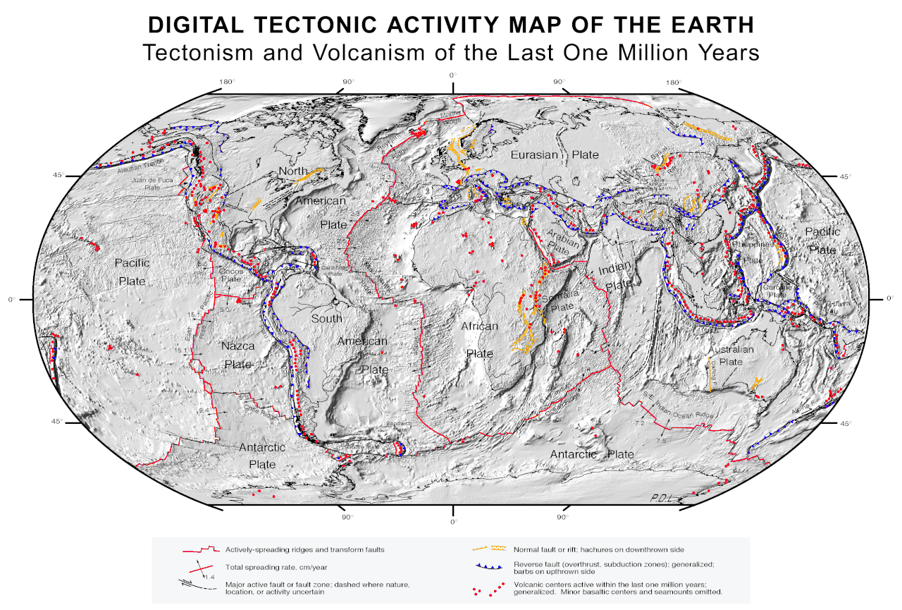
Red dots - Areas with volcanic activity in the last one million years
Yellow lines and Black lines and arrows - Fault or rift
Red lines - actively spreading rifts and transform faults
Blue lines - subduction zones
arrows on red lines - spreading rate cm per year
(http://en.wikipedia.org/wiki/Plate_tectonics)
There are several pieces of evidence behind the theory of seafloor spreading. They are: the igneous rock that makes up the oceanic crust; ages of the rock that makes up the oceanic crust; the magnetite pattern in the ridges.
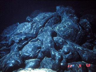
One of the pieces of evidence is the igneous rock that forms along the mid-ocean rift. Scientists were puzzled why and how igneous rock formed under the ocean. The answer is the mid-ocean rifts allowing magma flowing from the mantle to rise up and form igneous rocks.

(http://serc.carleton.edu/images/research_education/cyberinfrastructure/ridge/pillowlava.v2.jpg)

 Another piece of evidence is ages of the oceanic crust. Scientists have found out what age of the sea floor is. They have fully mapped out all the oceans on Earth. If you look at the map below you will see the ranges of the ages of the oceanic crust. The younger crust would be found closer to the rifts because that is where the new crust is being created and the oldest crust would be father away from the rifts because the older crust is being pushed away by the newly formed crust.

(http://0.tqn.com/d/geology/1/0/V/J/seafloorage.gif)


 A third piece of evidence are the magnetic stripes that shows when the Earth's magnetic poles were reversed. The magnetic strips form when the magma rises. There is a magnetic mineral called magnetite in the magma that aligns itself with the magnetic poles when the magma is not solid yet. On the oceanic crust there are 2 different variations of the magnetite that point in different directions. Scientists think that the poles reversed periodically during Earths history. Since the strips form symmetrically across the rift, it shows how the oceanic crust is pushed evenly in both directions.

(http://en.wikipedia.org/wiki/Magnetic_striping#Magnetic_striping)

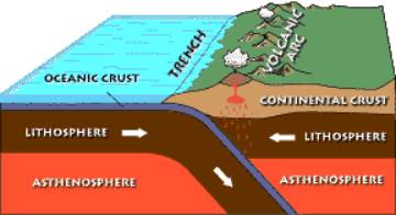
 Subduction at deep-ocean trenches determine whether the ocean grows or shrinks. If the oceanic crust subducts faster than the mid-ocean ridge expands, then the ocean would most likely shrink. If the trenches don't pull much under or are not there at all, then the ocean will most likely expand. When the oceanic crust subducts, the oceanic crust melts. Occasionally the melted material rises, because it is less dense, and forms a volcanic chain along the trench.

(http://www.vulkaner.no/v/vulkinfo/tomtech/image010.jpg)

 Currently, the mid-ocean ridges and deep-ocean trenches are hard at work changing the geography of the Earth. The Pacific Ocean is shrinking due to the amount of trenches surrounding it. Also the East Pacific Rise is much smaller than all the trenches combined. to compensate for the loss of ocean in the pacific, the Mid-Atlantic ridge is currently expanding the Atlantic because of the absence of trenches. The Indian Ocean is also growing larger too.

2- Mid-Ocean Ridges
3- Deep-Ocean Trenches
(http://www.geothermal-energy.org/pliki/Image/geo/What_is_geothermal_en_html_2f5bdb15.jpg)

 In class we made models of the mid-ocean ridges and deep-ocean trenches. The slits A and C represent the area where the paper/oceanic crust subducts. Slit B represents the mid-ocean ridge where the new crust is being formed. The paper that has slit A, B, and C (the black line below) in is the border between the lithosphere and the asthenosphere. The paper that goes through slits A, B, and C represents the oceanic crust. The different colored markings on the paper that goes through slots A, B, and C represent the magnetic stripes


Tuesday, December 4, 2012

Interior of the Earth by Emilija Iannace 12/2/12

The Earth is not just a hollow sphere covered in rocks as you might have once imagined.  It turns out that the inside of the Earth is made of hot and dense solid and liquid materials.  The interior of the Earth consists of four main layers.  From the surface, the layers progress from the Crust, Mantle, Outer Core, and Inner core. As you go deeper into the Earth the heat, pressure, and density increases.  Each layer is hotter than the next so more pressure and density is added on from the layer above.


Of the Earth’s four layers, the mantle has the most diverse material.  The mantle consists of layers called the Lithosphere and the Asthenosphere.  The Lithosphere is a solid layer of brittle rock made up of the very upper mantle and the crust.  The Asthenosphere is in the mantle right below the Lithosphere.  Its rock is solid but able to flow, like tar, because it is a little bit lower in the mantle and is hotter.


The crust is the Earth’s outer layer of land and ocean floor, and it is the thinnest, coolest layer, averaging 32 km thick.  The crust consists of  granite continental crust and basaltic oceanic crust. Continental crust is thicker than oceanic crust, but the granite is less dense, while the oceanic crust is thinner, but the basalt is more vast and dense.


As we now know, the Earth’s lithosphere and asthenosphere are the two different layers in the mantle.  The lithosphere is a lot thinner than the asthenosphere, and is made of the crust and the top of the mantle, so the materials inside are rock.  The asthenosphere is thicker and softer (hotter), so the materials inside slowly flow.  Both layers have rock materials and are above the mantle.


The Earth’s mantle is the next layer below the crust, and it contains the lithosphere and the asthenosphere.  The mantle plays a big part in the Earth’s shifting plates because it creates convection currents in the asthenosphere from the core’s heat.  If the convection currents flow in opposite direction, the heat pries apart the crust and causes rifting and earthquakes.  If the currents flow towards each other the plates collide and build mountains.


The outer core is thicker than the inner core, and it is full of molten metal, while the inner core is full of solid metal.  The inner core is almost twice as hot as the outer core.  They are both made up of nickel and iron, and together, they create the center of the Earth.


The Earth’s outer core is responsible for creating Earth’s magnetic field.  The molten nickel and iron of the outer core rotates, and the movement creates magnetic and electric charges.  Imagine that the Earth has a giant bar magnet inside of it.  The magnetic field is connected from the North end of the magnet to the South end.  The size of the field changes, and sometimes the field reverses (North Pole becomes South Pole).  The Earth’s magnetic field extends thousands of kilometers  into space, creating a sort of magnetic bubble called the magnetosphere.


In class we looked at half a hard-boiled egg and half an orange that could be used to describe the Earth and its layers. Both were strong representations of the Earth’s interior, but some parts also had weaknesses.  The hard-boiled egg had a thick, solid shell like the Earth’s crust.  The egg white made an accurate mantle, and the yolk was a good imitation of the whole core.  The only problem with the hard-boiled egg model was that it had an oval shape, unlike the round Earth.  Also, the whole core was solid, instead of the outer core being liquid with a solid inner core.  
The orange half had all of the layers, with an accurate crust, mantle and core.  The orange’s juicy flesh part showed a liquid core and a solid inner core.  The weaknesses of the orange half were that the outer core was too big and the inner core was too small.